Striated Pardalote (Yellow-tipped) [Nikon Z 9, Nikkor Z 800mm f/6.3 VR S @ 1/500s f/6.3 ISO180]
On 3 May 2025, a Striated Pardalote with a yellow dot on its wings was spotted in the Western Remnant. Victorian Striated Pardalotes (sub-species Ornatus and Substriatus) usually have red spots on their wings. This particular sub-species is call Striatus. It breeds in Tasmania but migrates to Victoria, New South Wales and Queensland in Winter.
I have known this sub-species of Striated Pardalote do visit Trin, however, this is the first time that I have actually spotted one. I would have preferred that it posed for me longer but I am relatively happy with this photograph as it depicts why it is a Striatus and I managed to capture quite a bit of detail. Besides, the sun was getting high in the sky making the light rather harsh.
Silvereye [Nikon Z 9, Nikkor Z 800mm f/6.3 VR S @ 1/500s f/6.3 ISO6400]
On 1 May 2025, I observed a flock of Silvereyes at Trin Warren Tam-boore. It is good to see that the Silvereye population is increasing again.
I managed to take this photograph of a Silvereye as it contemplated consuming the berries from a shrub. It did ended up consuming quite a bit of berries.
I was fairly close to the Silvereye which helped render the background into a pleasant blur. I have not had much success with photography in this particular spot in the past but I am glad it worked out this time.
Crimson Rosella [Nikon Z 9, Nikkor Z 800mm f/6.3 VR S @ 1/500s f/6.3 ISO1250]
28 April 2025 was a partly cloudy day and the morning was a bit crisp as autumn is slowly but surely setting in.
We were wandering at the Western Remnant of Royal Park when a couple of Crimson Rosellas made their presences known. I followed the Rosellas with my camera and managed to take this beautiful shot of one of the birds as it perched on a tree branch overhanging the railway cutting.
With the railway cutting rendered as a pastel peachy grey by the lens, the bright colour of the Rosella stood out complimented by the green leaves. This is possibly the best photograph of a Crimson Rosella that I have taken so far.
On 14 April 2025, we decided try to look for birds at a different location. Bababi Marning, also known as Cooper Street Grassland Nature Conservation Reserve. This location was host to Robins last Winter but I wasn’t aware of it until the Robins have vacated.
Since there have been many sightings for Robin in locations around Melbourne, I have decided to pay Bababi Marning a visit to find out if the Robin have arrived in this location.
Sadly, I did not observed any Robins but there were plenty of the usual birds that calls Melbourne home with the exception of Dusky Woodswallows. However, a much of Rainbow Lorikeets did caught my attention.
Many people consider these birds as a nuisance as they often feed on fruits grown in gardens. Their calls can be very annoying; perhaps second only to the Sulphur-crested Cockatoos. However, they are undeniably a very beautiful bird.
I was fortunate enough that these birds in Bababi Marning posed for me. They perched on a dead tree trunk on a bank of Merri Creek. As the oppose bank of the creek was reasonably far away, there was good isolation of the subjects.
While they were reasonably tolerant of my approach, they were flapping their wings while perched as if to increase the volume of their bodies to send me a warning. They really have no cause to be alarmed because there was a ditch separating me and them. When they depart their perch, I managed to capture one of them in flight.
The Rainbow Lorikeets may not be everyone’s favourite birds but they are without doubt one of the most photo-genic animals in Australia.
First: Nikon Z 9, Nikkor Z 800mm f/6.3 VR S @ 1/640s f/6.3 ISO1250
Second: Nikon Z 9, Nikkor Z 800mm f/6.3 VR S @ 1/3200s f/6.3 ISO4000
Third: Nikon Z 9, Nikkor Z 800mm f/6.3 VR S @ 1/640s f/6.3 ISO800
The sub-species Albiscapa of the Grey Fantail arrived at Trin late March – early April. This particularly sub-species spend their summer in Tasmania and their winters in the mainland.
The way to identity the sub-species is to wait until it fans its tail. In this sub-species, there is very little white on the tips of the tail feathers.
Grey Fantails are not the easiest birds to photograph, as they are frequently on the move and never stay still for very long. On 10 April 2025, one particular bird was kind enough to pose for me. Furthermore, it was at a location on a dead tree with background that is sufficient far away. This created a photographic opportunity that allow me to isolate the subject.
Although there were two Grey Fantail at the same location, these photographs are of the same bird. The other Fantail was more reserved and did not pose for photographs.
While I wished that more birds would pose for me, I understand that finding birds out in the open without protection of trees and shrubs is not in the nature of these animals. So, to me, this is a very special occasion. The bird allowed me to approach within 6 to 8 metres of it. As such, the photographs contained very imitate details.
First: Nikon Z 9, Nikkor Z 800mm f/6.3 VR S @ 1/500s f/6.3 ISO1400
Second: Nikon Z 9, Nikkor Z 800mm f/6.3 VR S @ 1/500s f/6.3 ISO1600
Third: Nikon Z 9, Nikkor Z 800mm f/6.3 VR S @ 1/500s f/6.3 ISO2200
Fourth: Nikon Z 9, Nikkor Z 800mm f/6.3 VR S @ 1/500s f/6.3 ISO2000
On 8 April 2024, as I approach the bird hide from the Skink Habitat, I spotted a large white bird in the pond. I had originally thought that it might be a Great Egret. On reaching the bird hide, it was obviously a Yellow-billed Spoonbill. What a surprise! This is the first time I have observed a Yellow-billed Spoonbill at this location.
While at the bird hide, I managed to take a few photographs. It then flew into Trin. When I followed it, I was pleasantly surprised to see another Royal Spoonbill. Whilst I have previously seen a Royal Spoonbill at Trin, it is still very rare. To have two species of Spoonbills in Trin at the same time must be very special indeed.
First: Nikon Z 9, Nikkor Z 800mm f/6.3 VR S @ 1/800s f/6.3 ISO220
Second: Nikon Z 9, Nikkor Z 800mm f/6.3 VR S @ 1/800s f/6.3 ISO400
On 19 March 2025, I was observing 2 Grey Fantails and a Brown Thornbill doing their thing at the Western Remnant of Royal Park. The Thornbill grabbed hold of a thin branch of a shrub right in front of me. I managed to capture this rather pleasing portrait of the Brown Thornbill.
Brown Thornbills are one of the smallest birds in Australia. Like many small birds, they never stay still at one place for very long. As a result, they are very difficult to photograph. All things considered, I am rather happy that this particular Thornbill stayed in the pose long enough for me to take this image.
Nikon Z 9, Nikkor Z 800mm f/6.3 VR S @ 1/500s f/6.3 ISO500
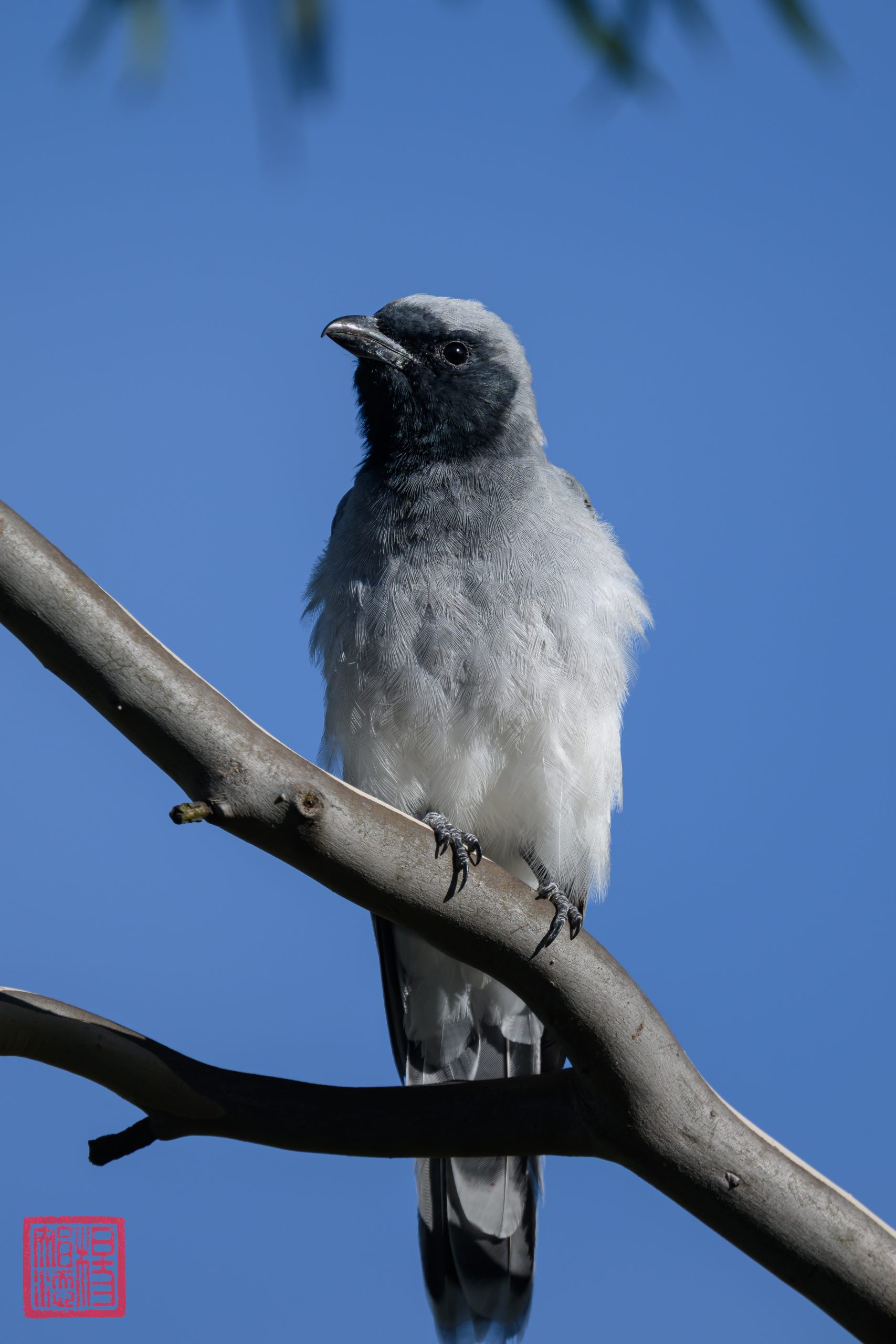
On 21 February 2025, I encountered 3 Black-faced Cuckooshrikes at the Western Remnant. I managed to take a photograph of what looked like a juvenile bird as it has downy looking feathers.
These birds usually perch in tall trees and are quite difficult to photograph at eye-level. As the path of the Western Remnant is elevated, I managed to photograph this particular bird at close to eye-level. The only issue is the featureless blue sky. I guess you can’t have everything.
Nikon Z 9, Nikkor Z 800mm f/6.3 VR S @ 1/800s f/6.3 ISO100
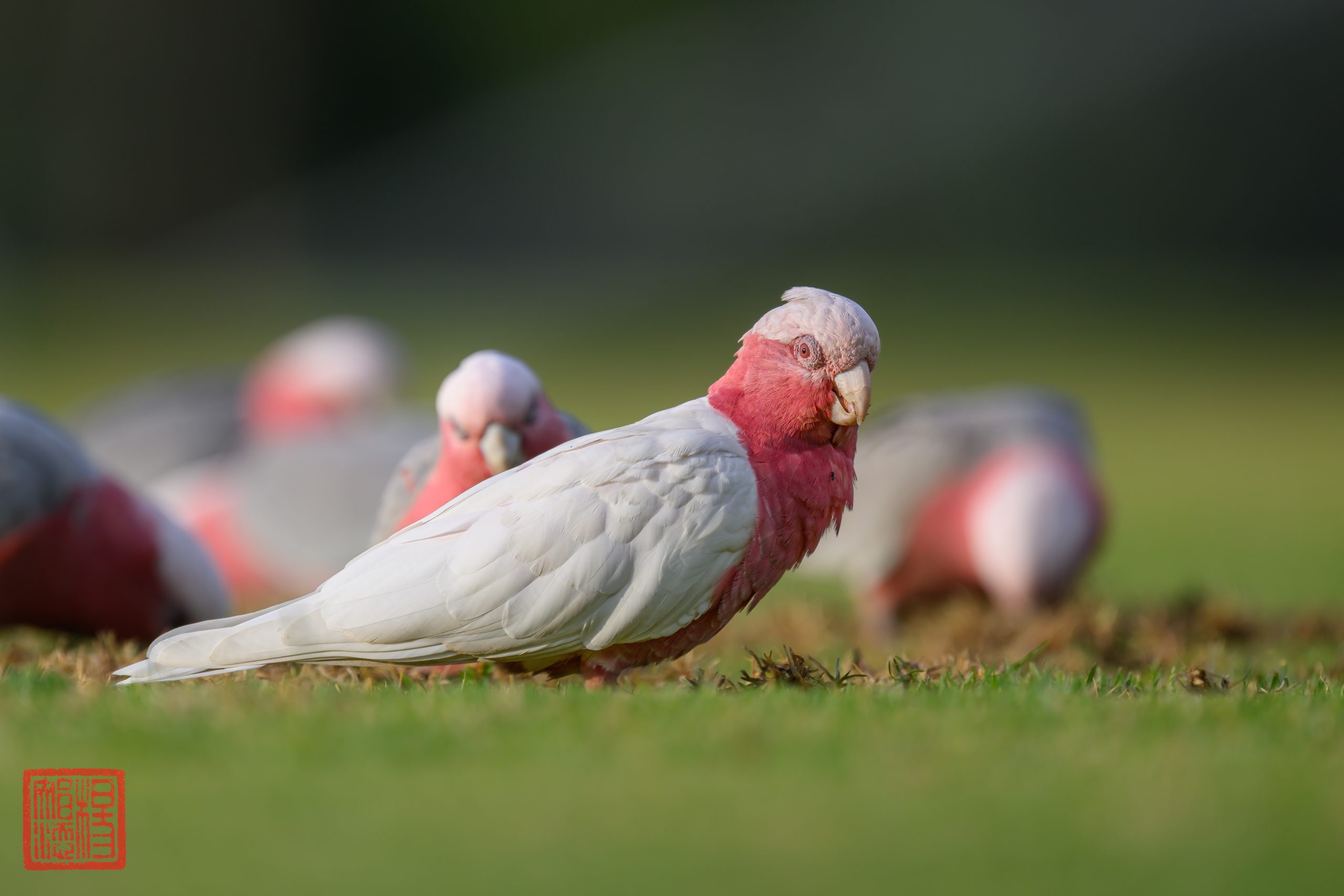
On 9 January 2025, I encountered this white-winged Galah on the oval next to Trin Warren Tam-boore, Royal Park.
If the eyes were any guide, it was a female. It is amongst the flock of Galahs. I have not had the fortune of seeing it after that encounter. I do wonder if it is a genetic defect or a phase that this particular Galah is going through.
Nikon Z 9, Nikkor Z 800mm f/6.3 VR S @ 1/640s f/6.3 ISO280.
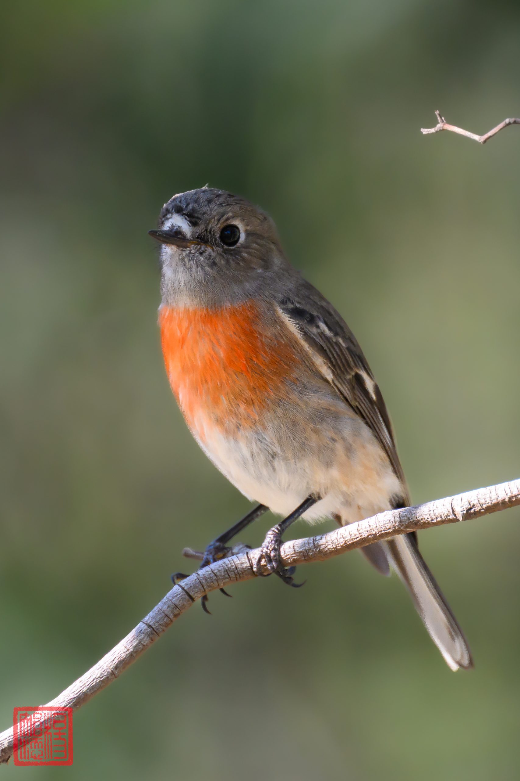
On 14 March 2025, a female Scarlet Robin was spotted at the Skink Habitat at Trin Warren Tam-boore, Royal Park.
From the side of my eye, there was a splash of orange-red colour. I originally thought that it may be a Mistletoebird but on closer look, it appeared to be a Robin. The colouration of the breast suggested that it was a female Scarlet Robin. I tracked her around the Skink Habitat and she eventually settled down and allowed me to take this photograph.
I often find Scarlet Robins easier to photograph than Flame Robins. They have a curious nature and has a smaller circle of fear. This is also the first time that I have observed a Scarlet Robin so close to Trin.
I am hoping that the sighting of this bird marks the beginning of the winter migration of the Robins to Melbourne.
Nikon Z 9, Nikkor Z 800mm f/6.3 VR S @ 1/800s f/6.3 ISO1000